
|
Plumstead and District photos
Brickfields
Brickfields Cottages (Victorian
era), note the Rockcliffe Gardens sign! Photo:
Alan Gibbs The Mill
The Old Mill, Plumstead Common, as it looked in the early 1800's
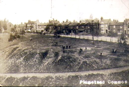
Winn's Common
“The Lakes” Winn's Common swimming lake 1880's. Later bomb damage in WWII and converted to play area and paddling pool.
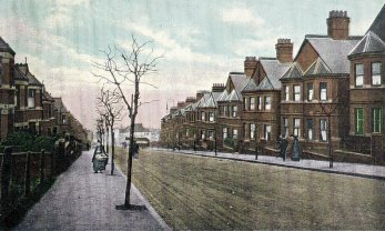
Streets & Roads
|
 including
Woolwich & Districts
including
Woolwich & Districts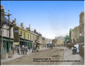


|
|
 Cook Family, C.1935 Cook Family, C.1935Edith Cook (Bunty), Catherine Cook (Bill), Aida Cook, Hilda Cook. (Click on photo for a larger view) |
 Walter Cook (Click on photo for larger view) |
 Aida Cook with daughter Bunty (Click on Photo for larger view) |
 Cooks Farm with Wickham Lane in the background. Mary Cook, a daughter of Walter and Aida, worked at the Blue Cross Kennels on Shooters Hill. (Click on photo for a larger view) |
 Postcard of Cooks Orchard Bostall Wood Plumstead (Click on photo for a larger view) |


Fire Station, Corner Lakedale Road and Plumstead
High Street c.1910. Photo: Greenwich Heritage Centre
(Click on picture for larger view)

Wickham Lane (View from Bostall Woods in 1911).
Photo: Alan Gibbs
Click on photo for larger view)
Shops

Cha-a'-banc outing, Prince Albert Pub, Ragland
Street, 1920's. Photo: Clare Crawford.
(Click on photo for a larger view)

Shop in 61 Bannockburn Road, 1950:
Photo: Terry Byatt
(Click on photo for a much larger view)
'My parents (Philip & Anne Byatt) and grandparents (Percy & Grace Hope) kept this shop, situated at 61 Bannockburn Road, from the late 1940’s until about 1955. I was two years old when they bought the shop, so many of my early childhood memories are around Plumstead. The shop was run during those hard times of post war rationing, as you can see from the photo, the shelves were not well stocked! - Terry Byatt

Photo:
Janet Gardner (nee Clisby)
My Dad Cyril Clisby and his brother Tom, taken
outside the shop their parents owned in
Plumstead in the 1920's,
I am not sure of the name of the road it was in,
but Villiers Place comes to mind. All I can
remember is if you went down Vicarage Park, you
seem to be continually walking down hill until
you came to a parade of shops.'
If anyone recognizes the shop and can remember where it was situated could they please let Pete know.

Godwin's Bakers shop. Photo: Les Parkins
Les says “At sometime around 1920 my grandfather,
William Godwin, ran a bakery. It was situated on
the corner of Riverdale and Speranza roads
Plumstead.
I am not sure how long he ran it for but think he
ran it into the 1930's.
The picture shows a shop window loaded with all kinds and types of bread and cakes.
The man in the picture is, I believe, George Taylor, the manager, and his family.”
King's Highway

Cottages
in King's Highway, c.1923. Photo: Greenwich Heritage Centre
(Click on photo for larger view)

A Mackintosh's ginger beer bottle. I've had this a few years now after I accepted as part payment for some work I did. (It's a long story!). Another of my 'treasured possessions' - Alan Read.
The War years

The plane, a yellow nosed
Messerschmitt Bf 109E, crashed in the front
garden of a cottage on the verge of a roadway in
Wickham Street on Sunday 20th October 1940.
Photo:
Ken Costin.
(click on photo for a larger view)
See story Messerschmitt
Bf 109E crash, Plumstead by Ken Costin

(Photo: via Ken Costin)
This aerial view of Genesta Road/Wrottesley Road looking south shows the extent of destruction in Plumstead caused by four V.1s in close proximity at Wrottesley Road, Admaston Road, Barnfield Road and Eglinton Hill/Herbert Road.
After this picture was taken, V.2 rockets in the vicinity added further destruction. Some other V.1 incidents in Plumstead, Woolwich and Abbey Wood were at Duncroft, 23 June; Swingate Lane, 1 July; Plumstead High Street/ Woodhurst Road, 30 July (fourteen people lost their lives); Hylton Street, 7 August (seven killed); Smithies Road, 18 June (six killed); Southern Outfall Works (four killed); Woodlands Farm, Shooters Hill Road, 24 August (no people hurt but sixty pigs killed).

Photo: Joe Duncan (Click on photo for a much larger view)
These are the remains of two German incendiary bombs that were dropped on Plumstead during WWII air raids in 1941. One landed in Timbercroft Lane and the other in Swingate Lane and these were picked up by a family member of Joe Duncan.'

Colin's dad, Frank Weightman, (Back row, left)
on duty as a fireman with the crew of the
Auxiliary Fire Service and their Tender at
junction of Winn's Common, on Lakedale and
King's Highway Roads sometime during the second
world war.
Maps

Map of the Prefabs on Plumstead and Winn's
Commons c.1943
(click on picture for a larger view)
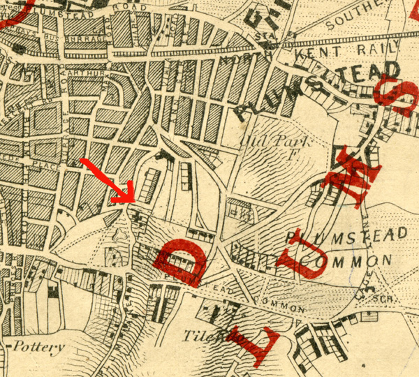
This old map is from an old Ordnance Survey Map
dated somewhere around 1860.

This map is from a London Guide Book dated 1994
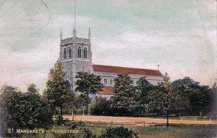
St. Margaret's Church

St Margaret's Church, Plumstead was built in the
1850's to accommodate the then expanding
working-class population of the district. For
more information click HERE
Photos: Alan Read

Photo: Clare Crawford.

Photo: Clare Crawford.

School children snow ball fun outside St Margaret's Church, Plumstead Common, in the very early 1900's. Photo: Kind permission of the 'Plumstead Common Environment Group'
St. Margaret's Church, 1951 now long demolished.
(Click on photo to visit originating site)
Photo: http://www.stevebulman.f9.co.uk/churches

Photo: Alan Read.
(Click on Photo for a larger view)
'The building with the name Vicarage
Park on the side of the building
was the Manse, or Vicarage, for St. Margaret's,
which is in the background.
Alas, this grand old church was pulled down, as
it was felt it was unsafe, and too costly to
rebuild.
The same thing happened to St. Mark's, however,
they built a new smaller Church on the St.
Mark's property, and the parish is now known as
St. Mark's & St. Margaret's on Plumstead
Common. —Bert Hooper

Harvey's Ladies Basketball Team 1947. Photo:
Alan Bristow
The game was played in the area of the Common
Old Mill Road and Warwick Terrace.
Harvey's were at one stage losing 7-2, I think
at half time, but eventually won 17-14.
I cannot recall the full names but as follows:
From left to right, back
row: Madge ? (sister of Vera), my
mother Florence Bristow, Vera Sweet.
Front row: ?, Louse,with cup,
Vera ?
Doreen ? the Captain was not in picture.
My mother was 33 at the time was the oldest team
member.
I used to go with my mother to support Harvey's.
I was ten at the time of the cup final.
PS. Harvey's and Stones were situated in Woolwich Road, Charlton.

Early Bus in Plumstead High Street (c. 1950's.)
(Click on photo for a larger view)

Chapman Bakers, on the corner of Griffin
Road and Plumstead High Street, tel: WOO 0388
Orchard Street is the next street on the right,
just past the 'New Cross Empire' poster and in
front of the Rose and Crown public house, which
is the last of the darker buildings, with a
large lamp in front. Photo: Helen Jones via John Boons web site.
(Click on photo for larger view)

(Photo; Roger Jewiss and shop info. from Harry
Lane.)
V.A.Vizzard, secondhand furniture
shop on Plumstead High street, 1950's. It was
situated near to the Police station and set back
a touch from the pavement and was next to the
old houses, and opposite the first house on the
other side of the road, next to the wall of
Bannockburn school, where there is now a bus
stop. The right hand potion of a Petrol Station
now stands on the site and was built in the
early 60s. On the Police station side of the
shop was the old Central Hall which was also
demolished to make way for the Petrol Station.
So the shop was between the Central Hall and the
old houses. The Plaza, which was about 350 yards
from the shop, is now Woolworth's. There were
however a number of other shops in between.
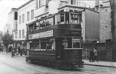
One of the old trams mentioned in many a story.
Photo: Alan Gibbs.
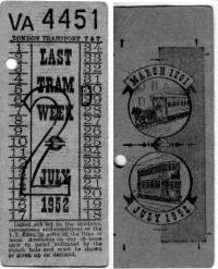
... and the very last, special issue, tram
tickets, July 1952.
Kindly donated by Alan Gibbs see story: Alan
Gibbs Remembers
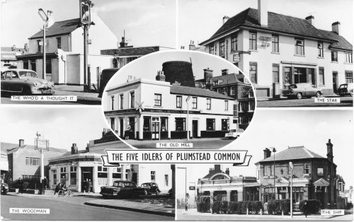
The "Idlers"

Postcard of Plumstead Common's famous “Five
Idlers”. Photo: Dierdre Terrant
(click on picture for a large view)
See poem The
Five Idlers of Plumstead Common
Another postcard of “The Five Idlers of
Plumstead Common”. Photo:Chris Kitchenham.
(Click on photo for VERY large view)

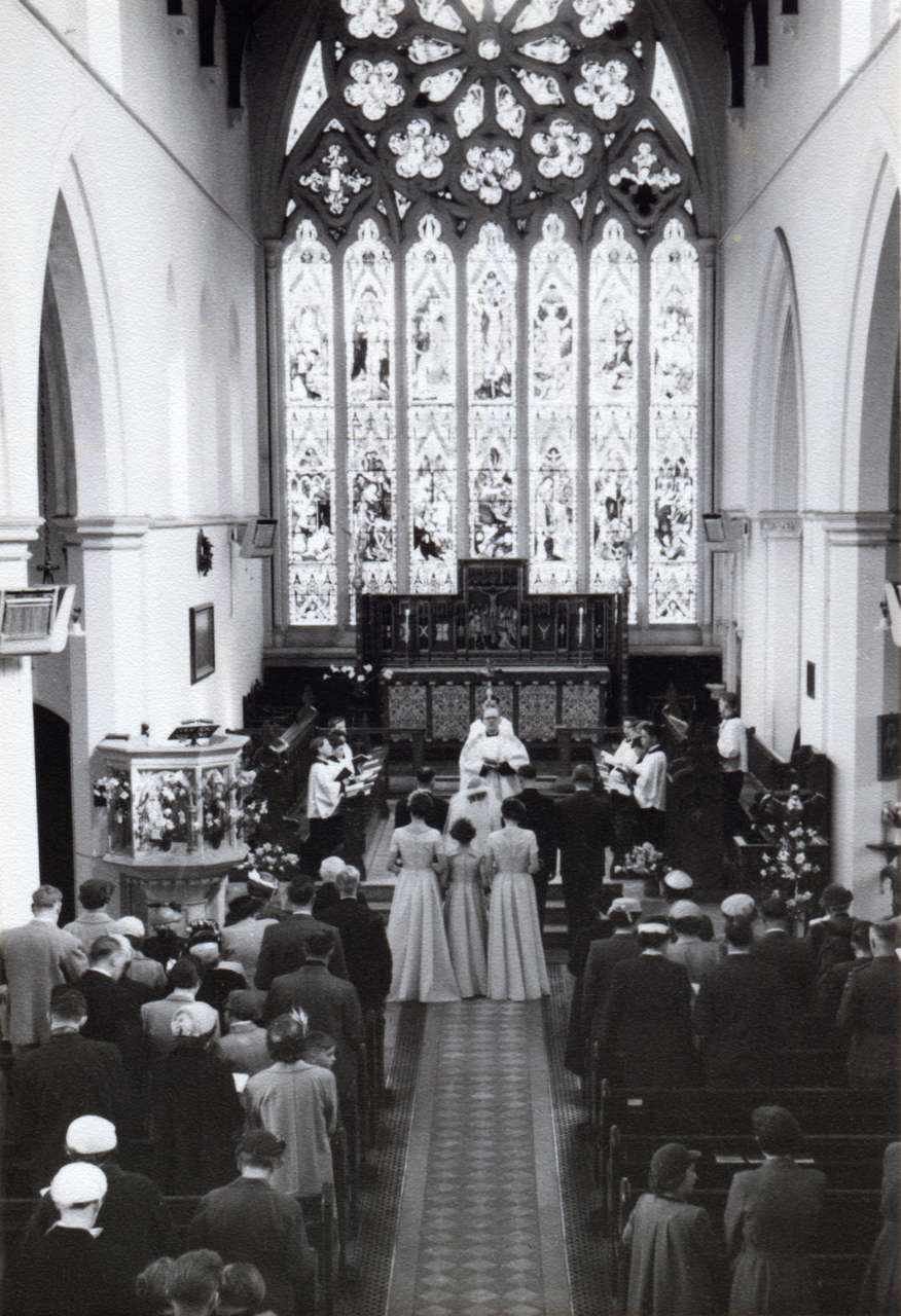
St Margaret's Church

Miriam and Peter Bastable's
wedding at St. Margaret's Church, Plumstead
Common, 1952.
My sister Sylvia Crooks is standing extreme
left and my other sister Dorothy Crooks is the
bridesmaid standing next to me. My brother
Victor is the middle of the children in the
front row.
St Margaret's Church was pulled
down when I went back to England in 1970; it
wasn't there.
Carl Forsythe made an amazing
find! So I found this photo album in a skip...
(dumpster)

"Our Wedding"
I saw this photo album in a skip in front of a house which was being cleared out by the council after the occupant had sadly passed away. The front cover is a little worn and the photos had some slight damage from 60+ years of storage. I scanned all twelve of the photos in at high resolution and carried out some light restoration work to remove dust and scratches.

"The Marriage"
Unfortunately, the happy couple never completed their details. The album was found outside a house in Dagenham, East London so it's likely that the wedding was local to that area.
The photos look like they were taken in the late 1940s or early 1950s.
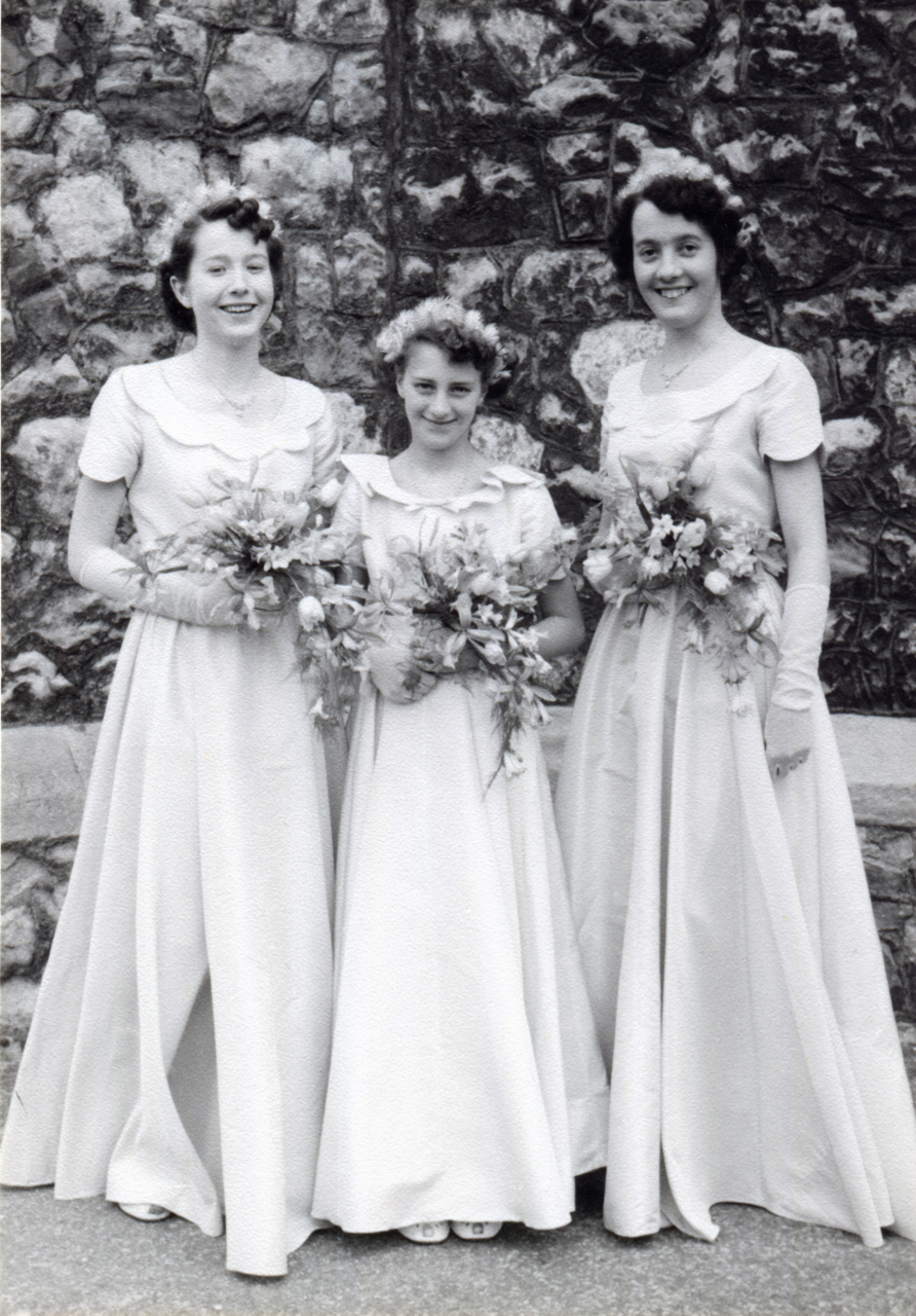
The Bridesmaids
This was the first image in the album.

A Nervous Husband-to-be
Photographed here, probably with his Best Man.

The Bride Arrives
Helped out of the car, most likely by her father.

The Bride photographed with her father(?)
Unlikely to be anybody else.
A packed church
St Margaret's was an awesome looking church.

First photograph together as husband and wife

"Congratulations"

The couple with the bridesmaids and the groom's best man

More close family members
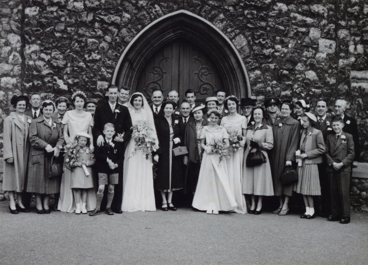
Extended family and friends
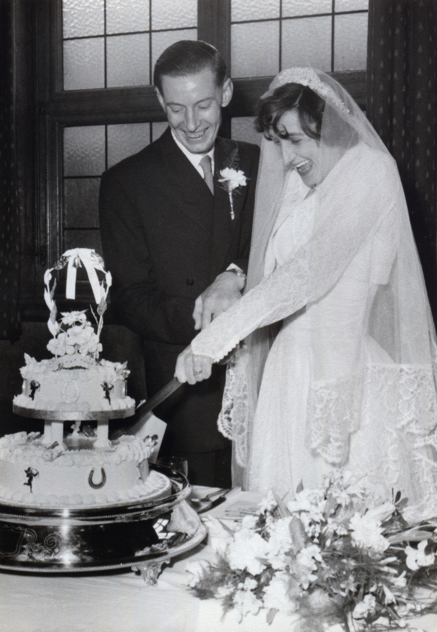
Cutting the cake together with a smile
These photos came from https://imgur.com/gallery/RJALT
How sad that this ended up in a skip. If anyone knows who they are or the story, please email me.
St. Nicholas Church

At St. Nicholas' Church in Plumstead is, where Auntie Ciss's son Ronnie married. Auntie Ciss (surname Strong) is to the left of Ronnie and Uncle Charlie to the left of her. My brother and myself are on the end of the front row - I think I'm about 13 years old by then. My sister is directly behind my brother and my Mum is behind her to the left.
Photo: Valerie Cunningham
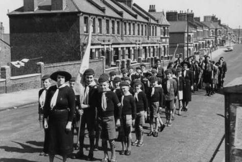
12th Woolwich Cub pack outside the East
Plumstead Baptist Church, corner of Griffin
& Brewery Roads, in preparation for their
annual St. Georges Day Parade march into
Woolwich, c.1954. Photo: Alan West.
Alan West is Standard Bearer.
See story Memories
of Childhood and My
Memories

St. Nicholas Hospital, now long
demolished and a housing estate built. Photo:
Joe Duncan. (Click on photo for a larger view)

A glimpse of St. Mark's (tower tops only are
visible) looking across Plumstead Common and the
ravine. Photo: Colin Weightman
See stories Clean
Lake, Dirty Lake, Our Lake Districts
and Baked
Spuds and Tea Leaves

Photo: Clare Crawford.
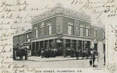
Photo: Clare Crawford.

My sister (Margaret) and I (John) sitting on my
father's motorbike (a Bartlett I think) on the
path of 48 Chestnut Rise. My father never could
and never did ride the motorbike.
Also in the photo is Bobby Fram who lived at 44.
He is playing cricket across the road using the
wall pillar as a wicket. You could not do this
now. Visited Chestnut last year...awful. The
road is of course choked with cars and my house
converted into flats.
Bob's father owned either a large Matchless or
AJS which he kept in the front garden. His
father also bred budgerigars and a room on the
rear grand level of the house was given up to
house them!
Photo: John Ball
(Click on photo for a larger view)

This photo was taken in the back garden of
neighbours...the Chambers. I am centre at the
back and my sister Margaret is first left and my
brother Graham next to her. They lived at 50
Chestnut and moved to a road off of Princess
Road in Dartford. Their new house was a semi
detached and had a side entrance and also had
French Doors. I thought they were rich! I also
thought they lived in the Country for although
you could get the LT Trolleybus 696 most other
transport was Greenline etc.
Photo: John Ball
The Links

“The Links”, Plumstead 1900's. Photo: Dr John Redman.

Plumstead
Common Road showing 'The Links', c.1905.
Photo: Greenwich Heritage Centre
(Click on photo for larger view)

A closer view of The Links - RACS
Co-op from the 1960's. Photo: Joe Duncan.
(Click on photo for a closer view)

The Links - RACS, Plumstead Common
1970's (from postcard)
Photo: Joe Duncan. (Click on photo for a larger
view)
The People's Hall

Kitchen in the People's Hall, 1884s. Photo: Dr
John Redman
(Click on photo for a larger view)

1902 Gallery and new front added to The People's
Hall. See further down for a close-up taken in
1929. Photo: Dr. John Redman
(Click on photo for a larger view)

People's Hall, 1929. Photo: Dr John Redman
(Click on photo for a larger view)

1985- The last Brigade Parade passing the old
“Peoples’ Hall” and the Woodman Pub as it turns
into Ravine Groove. Photo: Dr John Redman (Click
on photo for a larger view)

Outside the Slade Evangelical Church (2005) which was formerly the “People’s Hall”. Photo: Dr John Redman

St Patrick's School, where the boys played in
the playground up on the roof (near corner of
Griffin and Conway Roads about c.1998). Photo:
Bert Hooper
(Click on photo for a larger view)

Wickham Lane School (in the distance). Photo:
Bert Hooper
(Click on photo for a larger view)
Sometimes when we'd go over to Fanny
On The Hill, we'd come back either
through Rockcliffe Gardens, or along the road at
its side called
Southlands.
We'd often stop at the top of that hill and look
out at Bostall Woods, over
the Quarry and the subsiding houses on Alliance
Road.
Those old houses have long since been replaced
by more solid modern stuff,
and the site of the old Bus Garage is now a
Super Store.
Wickham Lane School still stands as a landmark
in the middle of the Plum
River Valley, (Bostall Woods at the back)
although we know that most of that stream is in
a pipe
that starts at the Glenmore Arms, and runs under
Fanny On The Hill.
Bert Hooper.

St. Margaret's School 2005. Photo: Joe Duncan

The old Plaza Cinema and former church,
Plumstead High Street (2005). Photo: Alan Gibbs
(Click on photo for a larger view)

Plumstead Common ravine pond (2005). Photo: Alan Gibbs.

Plumstead Common (2005) steps going up from the ravine pond by the end of Roydene Road. Photo: Alan Gibbs.

Plumstead Common, steps down to ravine pond from Lakedale Road. Three quarters of the way down on the right, there are some lovely old dwellings. Photo: Alan Gibbs.

'The walk to Wickham Lane School in the middle
of winter' as it would have been remembered by
Colin and others who trudged across here in
those earlier times on their way to and from
school, and of also passing the prefab village,
once a little community of folk, which was
situated on the right of the photo, on Wynn's
Common. (This is where the Arsenal Football Club
first began playing soccer and was established.)
Photo taken by Bert Hooper in 1997

The stillness of Bowman's Hollow c.1997.
Photo: Bert Hooper

Plumstead Common ravine with Sladedale Road houses in the middle distance. Photo: Alan Gibbs.